| Ⅰ | This article along with all titles and tags are the original content of AppNee. All rights reserved. To repost or reproduce, you must add an explicit footnote along with the URL to this article! |
| Ⅱ | Any manual or automated whole-website collecting/crawling behaviors are strictly prohibited. |
| Ⅲ | Any resources shared on AppNee are limited to personal study and research only, any form of commercial behaviors are strictly prohibited. Otherwise, you may receive a variety of copyright complaints and have to deal with them by yourself. |
| Ⅳ | Before using (especially downloading) any resources shared by AppNee, please first go to read our F.A.Q. page more or less. Otherwise, please bear all the consequences by yourself. |
| This work is licensed under a Creative Commons Attribution-NonCommercial-ShareAlike 4.0 International License. |
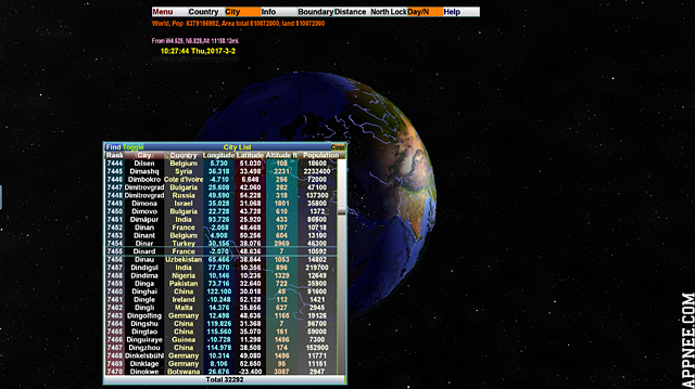
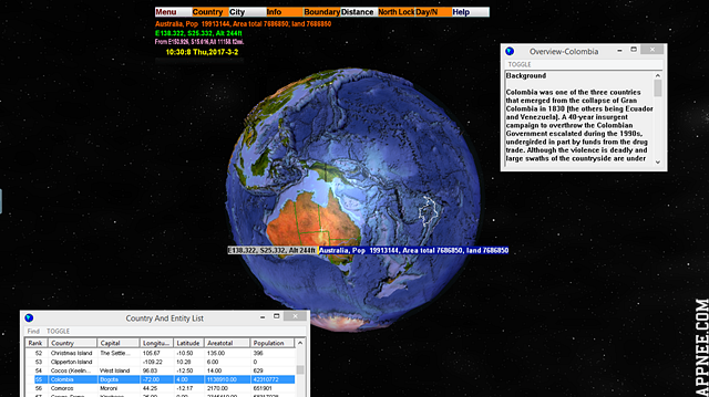
3D World Map is a powerful and high-definition three-dimensional world map (Note that: it is a ‘Map’ rather than ‘Earth’). It enables you to accurately find 269 countries and regions in the world on this realistic tellurion, and precisely displays the locations of more than 30000 cities around the world. Plus, it can calculate the distance between any two points on the earth, and all mountains, rivers, lakes and seas can be seen with a glance on this 3D tellurion.
Moreover, 3D World Map comes with convenient customization functions. From color to font, many details can be specified as you like. If you like, you are allowed to raise the sea level, so as to see the consequences of global warming. At the same time, 3D World Map also serves as a cool screen saver. Together with its built-in mini MP3 player, you can enjoy the beauty of looking down at the earth from outer space while listening to your fair-sounding music (some shocking ones are better).
// Key Features //
- Real 3D model of the earth
- Locate and compare more than 30000 cities in the world
- Built in mp3 player with spectrum analyzer
- Mp3 playlist editor
- Compute distance
- Password protection support(screensaver)
- Camera control(screensaver)
// Command Introductions //
- Show Tool Bars–This will show the tools bars and status bars. Only available in windowed mode and full screen mode.
- Unselect And Clear All–Clear all selections and distance lines.
- Windowed–Run the program in standard wimdow mode.
- Transparent–Run the program in transparent mode.
- Full Screen–Run the program in full screen.
- Always On Top–Keep the 3D World Map always on top.
- Save Location–Save the current location, so you can go back quickly by selecting the location. Pressing key 1,2….9,0 will bring up the location 1 to 10 you have saved.
- Delete Location–Delte any of the locations you have saved.
- Rotate Globe–Left draging will rotate the globe.
- Move Globe (Left Drag)–Left draging will move the globe.
- Zoom Globe (Left Right Drag Together)–Left draging will zoom in/out the globe.
- Distance–Toggle distance mode, you compute the distance between any two points on the globe.
- Center Globe (C)–Move the globe into the center of the window and make the north up.
- North Up Globe (U)–Turn the globe’s north up.
- North Up Lock–Keep the north up.
- Show Boundary–Draw political boundary.
- Show City–Show cities on the globe.
- Day/Night Toggle–Toggle day and night.
- City Browser–Open the city browser.
- Country Entity Browser–Open the country and entity browser.
- Country Entity Overview–display the overview of the selected country or entity.
- Floating Status Messages–Toggle the display of the floating status messages as you move the mouse.
- Metric Units(m, km)–Use metric units for altitude and distance.
- Options–Let you change some configurations.
- Add New Site–To add a new site.
// Keyboard Controls //
- Left Drag–Rotate the globe.
- Left Right Drag togehter–Zoom in/out a button,window or the globe.
- Right drag–Move the globe.
- Locate a city–Click a city on the globe, the city list window will scroll to this city, click a city in the city list window, the globe will turn around to the city.
- Compute Distance–Click Distance Button, click source point, then click target point, the distance will be displayed. You can display 16 sets of distance lines at the same time.
- City Button–Open /Close city list window.
- Country Button–Open /Close country list window.
- Day/N Button–Toggle On/Off Day/Night area.
- Boundary Button–Toggle On/Off boundary.
- Distance Button–Toggle On/Off distance mode.
- Infor Button–Open/Close country overview window.
- Center Button–Center the globe and make the north up.
- Help Button–Open/Close the readme.txt window.
- Exit Button–Exit.
- Esc–Exit.
// License Code //
| Regname (License name) | Regcode (License code) |
| AppNee.com | 572575935f6a8b2f8a043eee72fa3698 a382cda05f4afa669ba2854e07ba7136 57685384415fbfdc01f89c043d9ae1d6 83f22d3e2f0ad9a67b62658ee77a5176 |
// Edition Statement //
AppNee provides the 3D World Map portable full registered versions for Windows 32-bit and 64-bit, along with more details: topography file (30.9 MB) and texture file(6.83 MB).
// Installation Notes //
- Install 3D World Map main program
- Register with the license code above
- Install Globe Texture and Globe Topography to extend 3D World Map with more details
- Done, enjoy!
// Download URLs //
| Version | Download | Size |
| v2.1 Final |  |
37.9 MB |
(Homepage)
| If some download link is missing, and you do need it, just please send an email (along with post link and missing link) to remind us to reupload the missing file for you. And, give us some time to respond. | |
| If there is a password for an archive, it should be "appnee.com". | |
| Most of the reserved downloads (including the 32-bit version) can be requested to reupload via email. |