| Ⅰ | This article along with all titles and tags are the original content of AppNee. All rights reserved. To repost or reproduce, you must add an explicit footnote along with the URL to this article! |
| Ⅱ | Any manual or automated whole-website collecting/crawling behaviors are strictly prohibited. |
| Ⅲ | Any resources shared on AppNee are limited to personal study and research only, any form of commercial behaviors are strictly prohibited. Otherwise, you may receive a variety of copyright complaints and have to deal with them by yourself. |
| Ⅳ | Before using (especially downloading) any resources shared by AppNee, please first go to read our F.A.Q. page more or less. Otherwise, please bear all the consequences by yourself. |
| This work is licensed under a Creative Commons Attribution-NonCommercial-ShareAlike 4.0 International License. |
GPXSee is a free, open-source GPS log file viewing and analyzing tool, developed by Martin Tůma from Czech Republic. It comes with a friendly user interface and powerful features, and is mainly used to view and analyze the GPX file (which is the common file type that GPS devices record their waypoints, providing data for GPS navigation).
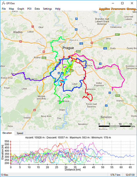
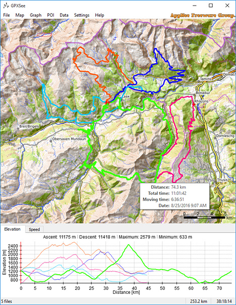
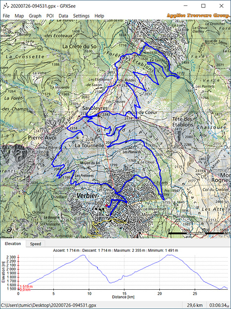
As a fast and uncomplicated GPS data/map viewer, GPXSee supports all the popular GPS compatible file formats (including GPX, TCX, KML, FIT, IGC, NMEA, SLF, SML, LOC, GPI, GeoJSON, Garmin CSV and OziExplorer Files), and is able to browse online maps, load offline maps, load POI files, support full-screen mode, display charts, display multiple tracks, mark geography and climate, display tracks, routes, navigation points, and more.
In addition, GPXSee has built-in coordinate setting and scale setting tools, so that users can quickly locate their location while looking at the geographical map. It also allows users to open multiple types of map files to view various map data. For example, you can select Open Street Map to open and view the street map file, use Open Topo Map to open and browse the topographic map, or you can also load the USGS images to check the geological information.
// Key Features //
- Opens GPX, TCX, FIT, KML, NMEA, IGC, CUP, SIGMA SLF, Suunto SML, LOC, GeoJSON, OziExplorer (PLT, RTE, WPT), Garmin GPI & CSV, TomTom OV2 & ITN and geotagged JPEG files.
- User-definable online maps (OpenStreetMap/Google tiles, WMTS, WMS, TMS, QuadTiles).
- Offline maps (OziExplorer maps, TrekBuddy maps/atlases, Garmin IMG/GMAP & JNX maps, TwoNav RMaps, GeoTIFF images, MBTiles, BSB charts, KMZ maps, AlpineQuest maps, Locus/OsmAnd/RMaps SQLite maps, Mapsforge maps, World-File georeferenced images).
- Elevation, speed, heart rate, cadence, power, temperature and gear ratio/shifts graphs.
- Support for DEM files (SRTM HGT).
- Support for POI files.
- Print and export to PNG and PDF.
- Multiple tracks in one view.
- Full-screen mode.
- HiDPI/Retina displays and maps support.
- Native GUI (Qt) for Windows, Mac OS X and Linux.
- Free software (GPLv3 open-source license).
// Related Links //
// Download URLs //
| License | Version | Download | Size |
| Freeware | Latest |  (mir1 | mir2) (mir1 | mir2) |
n/a |
(Homepage | SourceForge | GitHub)
| If some download link is missing, and you do need it, just please send an email (along with post link and missing link) to remind us to reupload the missing file for you. And, give us some time to respond. | |
| If there is a password for an archive, it should be "appnee.com". | |
| Most of the reserved downloads (including the 32-bit version) can be requested to reupload via email. |