| Ⅰ | This article along with all titles and tags are the original content of AppNee. All rights reserved. To repost or reproduce, you must add an explicit footnote along with the URL to this article! |
| Ⅱ | Any manual or automated whole-website collecting/crawling behaviors are strictly prohibited. |
| Ⅲ | Any resources shared on AppNee are limited to personal study and research only, any form of commercial behaviors are strictly prohibited. Otherwise, you may receive a variety of copyright complaints and have to deal with them by yourself. |
| Ⅳ | Before using (especially downloading) any resources shared by AppNee, please first go to read our F.A.Q. page more or less. Otherwise, please bear all the consequences by yourself. |
| This work is licensed under a Creative Commons Attribution-NonCommercial-ShareAlike 4.0 International License. |
Meteorological data includes the conventional ground meteorological data and the solar energy resource radiation data. In the actual development of photovoltaic power generation projects, most investors use the radiation data from relevant meteorological databases to calculate the photovoltaic power generating capacity. At present, NASA and Meteonorm are the main sources of solar energy radiation data for early site selection and revenue estimation of photovoltaic power stations. They are the industry standard of solar resource query software in the photovoltaic industry.
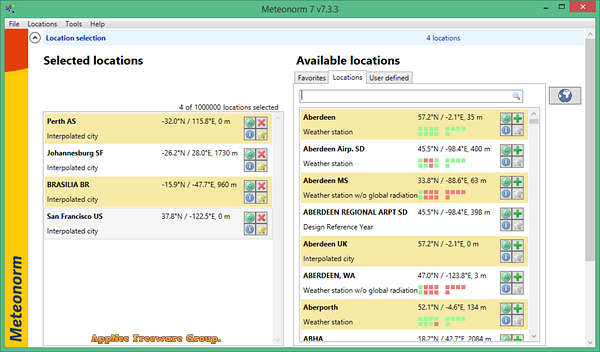
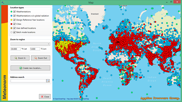
Meteonorm is a professional and powerful global historical meteorological information query & analysis software developed by Meteotest from Switzerland. Its database is provided by tens of thousands of weather stations and several geostationary satellites around the world, thus ensuring the authenticity and reliability of data. Meteonorm is suitable for engineers, architects, teachers, planners and anyone who are interested in solar energy and meteorology to use.
As an integrated meteorological database used for solar applications and system design, Meteonorm is a unique combination of reliable data sources and complex computing tools. You are allowed to choose from dozens of different weather parameters as needed. The program can calculate the solar radiation value on an arbitrarily oriented surface at any location. That is, input the latitude and longitude coordinates of a project site to easily obtain the average monthly total radiation in the region for decades.
In contrast, most of the time NASA’s data is higher than Meteonorm’s, with the maximum being more than 10%. Therefore, it is recommended to use Meteonorm’s data when calculating solar power generation. Or, if you find that NASA’s weather data isn’t accurate enough, then give Meteonorm a try. Meteonorm’s data is more accurate than NASA’s especially when the source of data can only be satellites. BTW, for photovoltaic power design software, you can ask PVsyst for help.
// Key Features //
| Feature | Description |
| Global coverage | Data from more than 8 000 weather stations worldwide and five geostationary satellites. |
| Data period | The standard periods are 1991–2010 / 1996–2015 for irradiation data and 2000–2009 for other parameters. |
| Time intervals | Meteonorm generates monthly, daily, hourly and minute values. |
| Historical time series | Historical hourly values of irradiation and temperature from 2010 to present, constantly updated. |
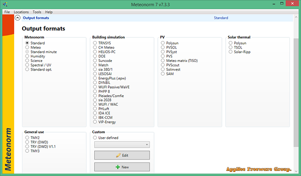
| Data formats | 36 output formats: CSV, TMY2, TMY3, EPW, PVSol, PVSyst, Polysun, SAM and many more. |
| Interpolation | Interpolation models calculate typical years for any location worldwide. |
| Aerosol climatology | Globally calibrated gridded dataset by Chris Gueymard. Time period 2000-2015, spatial resolution 0.5°. |
| API and DLL | The Meteonorm core is also available as Dynamic Link Library or Web Service for digital applications. |
| Current monthly values | Current monthly values can be accessed online directly from the software. |
| Uncertainty | Transparent information on data sources and uncertainty provided for each data set. Validation papers available on the website. |
| Urban Climate | Urban heat islands can be simulated. Specific urban climatologies for Bern and Vienna. |
| Climate change | Meteonorm includes three IPCC scenarios and allows projections to the year 2100. |
| Topography | Global 90x90m terrain model. Digitising tool for user-defined horizon lines. |
| Extreme years | P10 and P90 values available for simulating extreme years. |
| Data import | Third party data can be imported. |
| Parameters | More that 30 different meteorological parameters available. |
// System Requirements //
- Microsoft .NET Framework 4.7.2
// Edition Statement //
AppNee provides the Meteonorm multilingual full installers and universal license files for Windows 32-bit & 64-bit.
// Installation Notes //
for v7.3.3, v8.0.3:
- Download and extract program
- Copy the corresponding license file to the following path:
- C:\ProgramData\Meteotest\meteonorm(x)\
- Done
// Related Links //
// Download URLs //
| Version | Download | Size |
| v7.3.3 | reserved | 223 MB |
| v8.0.3 |  |
342 MB |
(Homepage)
| If some download link is missing, and you do need it, just please send an email (along with post link and missing link) to remind us to reupload the missing file for you. And, give us some time to respond. | |
| If there is a password for an archive, it should be "appnee.com". | |
| Most of the reserved downloads (including the 32-bit version) can be requested to reupload via email. |