| Ⅰ | This article along with all titles and tags are the original content of AppNee. All rights reserved. To repost or reproduce, you must add an explicit footnote along with the URL to this article! |
| Ⅱ | Any manual or automated whole-website collecting/crawling behaviors are strictly prohibited. |
| Ⅲ | Any resources shared on AppNee are limited to personal study and research only, any form of commercial behaviors are strictly prohibited. Otherwise, you may receive a variety of copyright complaints and have to deal with them by yourself. |
| Ⅳ | Before using (especially downloading) any resources shared by AppNee, please first go to read our F.A.Q. page more or less. Otherwise, please bear all the consequences by yourself. |
| This work is licensed under a Creative Commons Attribution-NonCommercial-ShareAlike 4.0 International License. |
OkMap is undoubtedly the favorite software of many outdoor enthusiasts. It can perfectly fit the Garmin or Magellan GPS devices, enabling your to quickly find your own position and work out the best route to take in various recreational activities, for example in the wild professional activities, in the outdoor sports, as well as in the nature (search and rescue, navigation, cross-country around mountains, mountain biking, hiking, rock climbing, picnic, outing, sea fishing, and other environment).
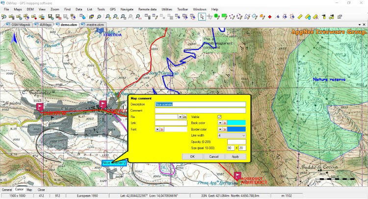
As an interactive GPS mapping software well suited for many outdoor enthusiasts, OkMap allows you to work on your computer screen using web maps or digital maps that you have purchased or scanned. It supports the import of vector data from the most common map formats and height information relevant DEM data. With these maps, you can organize your paths by creating waypoints, routes and tracks on your computer monitor, and upload these datas to your GPS device. In addition, OkMap can automatically set the altitude data, estimate the travel time, and provide you with automatic routing and geocoding capabilities.
The data collected by your GPS device can be downloaded to your computer, then stored and displayed on a map. They also can be used to create different types of statistics. By connecting GPS to computer, you can draw your location on a map in real time. If you are connected to the Internet, you can constantly send your location data to a remote computer, or receive a companion’s location info on computer, and display the relevant tracks on a map in real time. OkMap is also able to connect to Google Maps and Google Earth. With help of Google Maps, you can get parts of the map immediately in OkMap; while with help of Google Earth, you can view paths and maps in the 3D perspective.
// Key Features //
- Display web maps for more than 200 servers (Google, Apple, OpenStreetMap, ESRI, USGS, Kompass, IGM, …)
- Italian cadastral layers: buildings, parcels, lines of dressing and zoning
- Ability to add new custom web map servers
- Calibration / display raster maps (over 30 image formats) (video)
- Display vectorial maps
- Display hybrid maps (raster + vectorial data)
- Ability to open multiple maps simultaneously
- 15 cartographic projections of the most used
- Representation of coordinates in: degrees, degrees-minutes, degrees-minutes-seconds, UTM, ECEF, Open Location Code, GeoRef, USNG (US National Grid), MGRS (Military Grid Reference System), BG (British Grid), IG (Irish Grid), metric coordinates with custom projections
- Database with over 760 datum
- Database with about 3400 predefined projections by geographic area
- Viewing 3D raster maps on Google Earth (for supported image formats)
- Projects management (meta files)
- Full screen map view
- Map add-ons management (icons, comments)
- Vectorial data management (point, multipoint, line, polygon)
- GPX data management (waypoints, tracks, routes)
- Files manager
- Selecting multiple objects with the mouse
- Context menu (right mouse)
- Auto-info function
- Zoom, autofit, zoom on selected objects functions
- Moving map function in 3 modes
- Docking forms
- Customizing toolbar
- Showing yes / no toolbar
- Showing yes / no statusbar
- Check new releases at startup
// Main Applications //
- Search and rescue
- Trekking
- Mountain bike
- Off road
- Boating
- Flying
- Hunting and fishing
- Finding mushrooms
- Geocaching
- Soft air
// Supported GPS Devices //
| Receive GPX data from | Send GPX data to |
| Brauniger IQ series, Garmin, GlobalSat DG-100/BT-335, GlobalSat DG-200, GlobalSat GH625XT, Holux M-241, Magellan, MiniHomer, MTK Logger, NaviGPS GT-11/BGT-11, SysTraq Venus, Wintec WBT-100/200 | Garmin, GlobalSat GH625XT, Magellan, NaviGPS GT-11/BGT-11 |
| Upload/download | NMEA navigation |
| All new GPS devices that are handled as a mass storage device + Brauniger IQ series, DeLorme PN20/30/40, Garmin, GlobalSat DG-100/DG-200/BT-335, Holux M-241, Magellan, MiniHomer, MTK Logger, NaviGPS GT-11/BGT-11, SysTraq Venus, Wintec WBT-100/200 | All GPS devices that support Nmea 0183 protocol |
// Supported Projections //
- Albers Conical Equal Area
- Bonne
- Cassini
- Hotine Oblique Mercator
- Lambert Azimuthal Equal Area
- Lambert Conformal Conic
- Lambert Conformal Conic 2SP
- Longitude/Latitude (Equidistant Cylindrical / Plate Carrée)
- Mercator 1SP
- Mercator 2SP
- Mercator spherical
- Oblique Mercator
- Orthographic
- Swiss Oblique Cylindrical
- Transverse Mercator
// Supported File Formats //
| Type | Format |
| Images | ECW, BMP, GIF, JPG, PNG, TIF and many others |
| Load maps | GFW, JGW, PGW, TFW, BPW (World file); ECW (Earth Resource Mapping); KML/KMZ (Google Earth, Garmin Custom Maps); EKMZ (Encrypted KMZ); JNX Birdseye (one level, small maps); GeoTiff; OziExplorer; CompeGps; GPS TrackMaker; RMap; MBTiles; OruxMap; GpsTuner |
| Load maps via GDAL | supported formats |
| Save maps | GeoTiff; World file; Garmin custom maps; KML/KMZ; JNX Birdseye; OziExplorer; OruxMaps; TomTom map overlays; GpsTuner |
| Save maps via GDAL | MBTiles, RMap and other supported formats |
| Maps tiling | Garmin custom maps; KML, KMZ, JNX, OruxMaps, TomTom map overlays and OkMap |
| Vectorial data | SHP, DBF (Esri shape file); DCW (Digital Chart of World) |
| GPS data | GPX; CompeGPS, EasyGPS, Fugawi, Garmin (various formats), Geocaching LOC, Google Earth (KML/KMZ), GPS TrackMaker, Kompass, NMEA, OpenStreetMap, OziExplorer, Tom Tom and many others formats thanks to the software GpsBabel |
| DEM data | HGT (SRTM-1 and SRTM-3) |
// System Requirements //
- Microsoft .NET Framework 4.7.2
- Microsoft Edge Chromium
- Microsoft Visual C++ 2015~2019 Redistributable Packages
// Edition Statement //
AppNee provides the OkMap Desktop multilingual full installers and unlocked files, as well as portable full registered versions for Windows 32-bit and 64-bit.
// Installation Notes //
for v18.2.1:
- Install OkMap Desktop
- Run the activator, and click ‘Activate‘
- Done
// Warning //
The activator might be reported as Win32:RATX-gen [Trj] threat with high risk. Use VirusTotal to make a full, authoritative scan, and decide to use it or not by yourself.
*** Please remember: antivirus software is not always right, just be careful and use it at your own risk.
// Related Links //
// Download URLs //
| License | Version | Download | Size |
| OkMap Desktop | v14.13.1 | reserved | 91.0 MB |
| v15.5.0 | reserved | 91.1 MB | |
| v16.2.0 | reserved | 97.2 MB | |
| v17.8.0 | reserved | 167 MB | |
| v18.2.1 |  |
42.9 MB |
(Homepage)
| If some download link is missing, and you do need it, just please send an email (along with post link and missing link) to remind us to reupload the missing file for you. And, give us some time to respond. | |
| If there is a password for an archive, it should be "appnee.com". | |
| Most of the reserved downloads (including the 32-bit version) can be requested to reupload via email. |