| Ⅰ | This article along with all titles and tags are the original content of AppNee. All rights reserved. To repost or reproduce, you must add an explicit footnote along with the URL to this article! |
| Ⅱ | Any manual or automated whole-website collecting/crawling behaviors are strictly prohibited. |
| Ⅲ | Any resources shared on AppNee are limited to personal study and research only, any form of commercial behaviors are strictly prohibited. Otherwise, you may receive a variety of copyright complaints and have to deal with them by yourself. |
| Ⅳ | Before using (especially downloading) any resources shared by AppNee, please first go to read our F.A.Q. page more or less. Otherwise, please bear all the consequences by yourself. |
| This work is licensed under a Creative Commons Attribution-NonCommercial-ShareAlike 4.0 International License. |

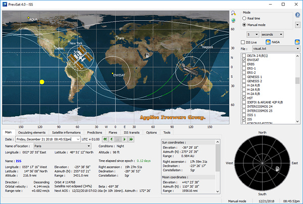
PreviSat (may be the successor of TLE Analyser) is a free, open-source and multi-functional satellite real-time tracking software for Windows, Mac and Linux platforms, developed by astropedia from France. By analyzing the Two-Line Element (TLE) data published and updated regularly by United States Space Surveillance Network (SSN), it can achieve accurate prediction and tracking of satellite orbit, and simultaneously analyze the TLE parameters of hundreds of in-orbit targets.
PreviSat can display the position and trajectory of the satellites on a world map or sky map (for selected observation points), enabling users to see the position of satellite in a variety of coordinate systems. It has two modes of operation: real-time mode and manual mode, the latter can display the location of satellite of any date. In addition, it also provides many options for customizing the display of graphical interface elements, and allows to group the most commonly used observation points.
PreviSat is able to help user mark the coordinates of artificial satellites in real time, and calculate the orbit of satellites through its powerful AI computing technology, so as to meet users’ needs for tracking and management of artificial satellites. At the same time, it can also help users collect the location info of the sun and moon, so as to meet the diversified needs of astronomy enthusiasts.
// Key Features //
- NORAD SGP4 model (Hoots, Roehrich, 1980; Vallado, 2006)
- Real time / Manual mode / Simulation mode
- World map / Sky map
- ISS Live and Wall Command Center visualization
- Topocentric / Equatorial / Terrestrial coordinates (satellites, Sun, Moon)
- Osculating elements, satellite information
- Weather for observer location and NASA bases
- Intuitive interface (handling of TLE, selection of location, options for display)
- Prediction of passes, MetOp and SkyMed flares, ISS transits and orbital events (very fast calculations)
- Satellite data search (all objects referenced by NORAD since 1957)
- Available for Windows/Linux/MacOS X platforms
// Related Links //
- PreviSat User Manual (PDF)
// Download URLs //
| License | Version | Download | Size |
| Freeware | Latest |  |
n/a |
(Homepage)
| If some download link is missing, and you do need it, just please send an email (along with post link and missing link) to remind us to reupload the missing file for you. And, give us some time to respond. | |
| If there is a password for an archive, it should be "appnee.com". | |
| Most of the reserved downloads (including the 32-bit version) can be requested to reupload via email. |