| Ⅰ | This article along with all titles and tags are the original content of AppNee. All rights reserved. To repost or reproduce, you must add an explicit footnote along with the URL to this article! |
| Ⅱ | Any manual or automated whole-website collecting/crawling behaviors are strictly prohibited. |
| Ⅲ | Any resources shared on AppNee are limited to personal study and research only, any form of commercial behaviors are strictly prohibited. Otherwise, you may receive a variety of copyright complaints and have to deal with them by yourself. |
| Ⅳ | Before using (especially downloading) any resources shared by AppNee, please first go to read our F.A.Q. page more or less. Otherwise, please bear all the consequences by yourself. |
| This work is licensed under a Creative Commons Attribution-NonCommercial-ShareAlike 4.0 International License. |
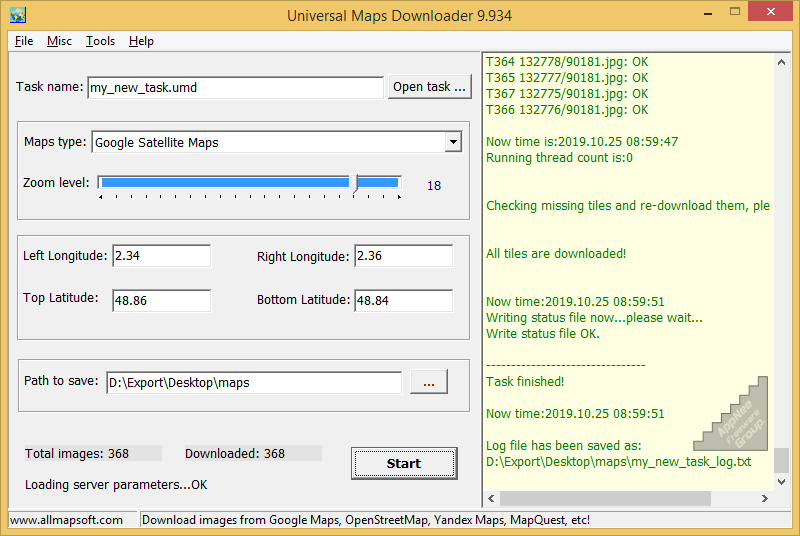
Universal Maps Downloader is a small and handy tool specially designed to download satellite maps from 150+ online map services. It can download map tiles based on the user-defined latitude and longitude scope, and save them on the local disk. Although it supports multi-threaded downloading, I recommend that you use it with setting neither too big scope nor too many download threads.
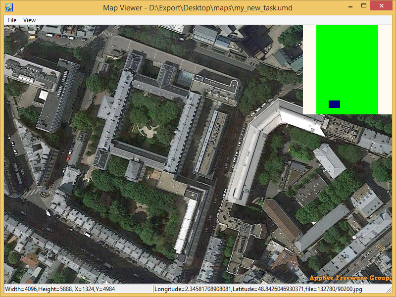
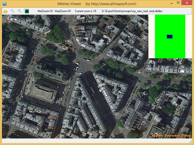
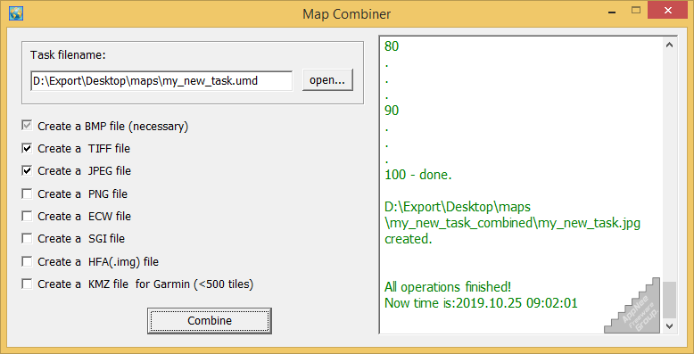
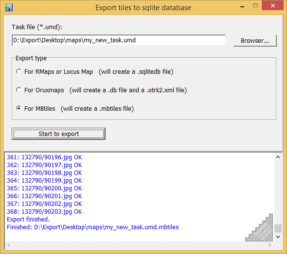
As a simple and compact universal maps downloading program, Universal Maps Downloader helps user get small tile images from all the popular map services around the world. All the downloaded small images are stored on local drive. User can use the built-in Maps Viewer to direct view the downloaded offline maps, and combine them into a large, complete BMP/TIFF/JPG/PNG/ECW/SIG/IMG format of map through the Maps Combiner. Moreover, you are allowed to export all the tiles as a MBTiles format of database file if desired.
Universal Maps Downloader is able to handle various Google layers, such as satellite, street view, traffic and blending, as well as Bing and many other online map services. After specifying the latitude & longitude and determining the map type, you can also set the zoom level, add tags on the map, and so on. If you have a fast Internet connection, the maps will be downloaded and stored smoothly. Besides, this software also provides SQLite output, so that mobile developers typically use this output for their applications.
// Supported Map Types //
- Multi-zoom level download
- KML/GPX support
- Output as large BMP file
- Output as large JPG/PNG/TIF file
- Export to sqlitedb(for Oruxmaps/RMaps/LocusMap)
- Google Satellite Maps
- Google Satellite Maps(64px tile)
- Google Satellite Maps(128px tile)
- Google Satellite Maps(512px tile)
- Google Satellite Maps(768px tile)
- Google Satellite Maps(1024px tile)
- Google Street Maps(local language)
- Google Street Maps(local language, 128px tile)
- Google Street Maps(local language,HD)
- Google Street Maps(local language,768px tile)
- Google Street Maps(local language,1024px tile)
- Google Street Maps(English)
- Google Street Maps(English,HD)
- Google Street Maps without labels
- Google Street Maps without labels(HD)
- Google Street Maps without POI
- Google Street Maps without POI(HD)
- Google Street Maps only labels(local language,HD)
- Google Street Maps only labels(English,HD)
- Google Terrain Maps
- Google Terrain Maps(HD)
- Google Terrain Maps with Roads(no labels)
- Google Terrain Maps with Roads(no labels,HD)
- Google Terrain Maps with Roads(local language)
- Google Terrain Maps with Roads(local language,HD)
- Google Terrain Maps with Roads(English)
- Google Terrain Maps with Roads(English,HD)
- Google Terrain Maps with Roads(English,768px tile)
- Google Terrain Maps with Roads(English,1024px tile)
- Google Hybrid Maps(local language)
- Google Hybrid Maps(local language,HD)
- Google Hybrid Maps(English)
- Google Hybrid Maps(English,HD)
- Google Street Maps for China (local langugage)
- Google Street Maps for China (local lang, HD)
- Google Street Maps for China (Chinese)
- Google Street Maps for China (Chinese, HD)
- Google Terrain Maps for China (local langugage)
- Google Terrain Maps for China (local lang, HD)
- Google Terrain Maps for China (Chinese)
- Google Terrain Maps for China (Chinese, HD)
- Yahoo Street Maps
- Yahoo Street Maps(HD)
- Yahoo Satellite Maps
- Yahoo Satellite Maps(HD)
- Yahoo Hybrid Maps
- Yahoo Hybrid Maps(HD)
- OpenStreetMap map
- OpenStreetMap transport
- OpenStreetMap cycle map
- OpenStreetMap OpenTopoMap
- OpenStreetMap Humanitarian
- OSM no labels
- OSM BW mapnik
- The National Map Normal (United States)
- The National Map Satellite (United States)
- The National Map Hybrid (United States)
- Yandex Map (Russian, Russia)
- Yandex Map (English, Russia)
- Yandex Satellite Map (Russia)
- Yandex Hybrid (English, Russia)
- Yandex Hybrid (Russian, Russia)
- Here normal map
- Here satellite map
- Here terrain map
- Here hybrid map
- MapQuest map
- MapQuest satellite
- virtual earth Street Maps
- virtual earth Satellite Maps
- virtual earth Hybrid Maps
- Ordnance Survey Maps (United Kingdom)
- Gaode satellite map (China)
- Gaode normal map (China)
- Gaode roads only (China)
- Tencent satellite map (China)
- Tencent terrain map (China)
- Tencent normal map (China)
- Baidu satellite map (China)
- Baidu map (China)
- Tianditu satellite map (Lat/Long) (China)
- Tianditu vector map (Lat/Long) (China)
- Tianditu terrain map (Lat/Long) (China)
- Tianditu satellite map (Mercator) (China)
- Tianditu vector map (Mercator) (China)
- Tianditu terrain map (Mercator) (China)
- Mappy Map (www.mappy.com)
- Mappy Satellite (www.mappy.com)
- ViaMichelin Map
- ViaMichelin Simplified
- ViaMichelin Outdoors
- ViaMichelin Hybrid
- ArcGIS Online Topographic
- ArcGIS Online Imagery
- ArcGIS Online Imagery with Labels
- ArcGIS Online Streets
- ArcGIS Online National Geographic
- ArcGIS Online Terrain
- ArcGIS Online Terrain with Labels
- ArcGIS Online USA Topo Maps
- ArcGIS Online USGS National Map
- ArcGIS Online Dark Grey Base
- ArcGIS Online Light Grey Base
- ArcGIS Online Oceans Base
- ArcGIS ChinaOnlineCommunity
- ArcGIS ChinaOnlineStreetGray
- ArcGIS ChinaOnlineStreetPurplishBlue
- Whereis Map (Australia)
- Whereis Satellite (Australia)
- Whereis Hybrid (Australia)
- Mapy.cz base map
- Mapy.cz aerial map
- Mapy.cz tourist map
- Mapy.cz Geography map
- Mapy.cz Winter map
- Mapy.cz Hybrid(Aerial with labels) map
- OneMap Default style (Singapore)
- OneMap Original style (Singapore)
- Map of Europe (beta.map1.eu)
- Waze Livemap
- Wikimapia (English)
- Wikimapia (Chinese)
- Wikimapia (Espanol)
- Maps.marshruty.ru
- Sentinel-2 map
- Maps.stamen.com Watercolor
- Maps.stamen.com Toner
- Maps.stamen.com Terrain
- Maps.stamen.com Terrain-background
- Maps.stamen.com Terrain-lines
- Maps.stamen.com Terrain-labels
- Hikebikemap.org
- Shipxy.com map
- Supermap (China)
- Strava Global Heatmap all hot
- Strava Global Heatmap all blue
- Strava Global Heatmap all grey
- Strava Global Heatmap all bluered
- GoMap.Az (AzerBaijan)
- Longdo Map (Thai, Thailand)
- Longdo Map (English, Thailand)
- Bhuvan-2D Map Base Admin (India)
- Bhuvan-2D Map Base Hydrology (India)
- Bhuvan-2D Map Terrain (India)
- Bhuvan-2D Map Satellite (India)
- Bhuvan-2D Map Hybrid (India)
- National Map Australian Topography (Australia)
- National Map Positron Light (Australia)
- National Map Dark Matter (Australia)
- New Zealand Topographic Maps (New Zealand)
- Map of UAE (United Arab Emirates)
- MapFan Standard Japanese (Japan)
- MapFan Standard English (Japan)
- MapFan Standard Chinese Simplified (Japan)
- MapFan Standard Chinese Traditional (Japan)
- MapFan Tourism Japanese (Japan)
- MapFan Tourism English (Japan)
- MapFan RPG style Japanese (Japan)
- MapFan Antique style Japanese (Japan)
- Yahoo Japan Map, Normal Map (Japan)
- Yahoo Japan Map, Satellite Map (Japan)
- Yahoo Japan Map, Railway Map (Japan)
- Yahoo Japan Map, Vivid Map (Japan)
- Yahoo Japan Map, Bold Map (Japan)
- Yahoo Japan Map, Waters Map (Japan)
- Yahoo Japan Map, Topographic Map (Japan)
- Freemap Slovakia Hiking (frermap.sk)
- Freemap Slovakia Bicycle (frermap.sk)
- Freemap Slovakia Car (frermap.sk)
- Freemap Slovakia Ski (frermap.sk)
- UMP-PC.pl (mapa.ump.waw.pl)
- 4UMaps (www.4umaps.com)
- Vietbando Maps (Vietnam)
- Vietbando Maps Terrain (Vietnam)
// Universal Serial Numbers //
- RBSXO-UOLPL-DNEGX-VBBTH-QEHLB
- WSOUZ-OUXVY-VNWGX-UYVYB-ZEUXV
- PLPSV-ZHOPJ-MNTGS-WZBXF-JNHEN
- ZSMWC-JOVKN-SKUFG-GWBKV-CBEYT
- FJSSQ-OYAFX-NKJXI-GRMBY-WEKHN
// Edition Statement //
AppNee provides the Universal Maps Downloader multilingual full installers and all versions universal serial numbers, as well as portable full registered versions for Windows 32-bit & 64-bit.
// Installation Notes //
for v7.xxx+:
- Download and install the latest version of Universal Maps Downloader from official site
- Launch program, enter “Help/Register…“
- Use the universal serial number above to register
- Restart program
- Done
// Prompts //
- The downloaded map images are for your personal and non-commercial purposes only.
// Related Links //
// Download URLs //
| Version | Download | Size |
| Latest |  |
n/a |
(Homepage)
| If some download link is missing, and you do need it, just please send an email (along with post link and missing link) to remind us to reupload the missing file for you. And, give us some time to respond. | |
| If there is a password for an archive, it should be "appnee.com". | |
| Most of the reserved downloads (including the 32-bit version) can be requested to reupload via email. |