| Ⅰ | This article along with all titles and tags are the original content of AppNee. All rights reserved. To repost or reproduce, you must add an explicit footnote along with the URL to this article! |
| Ⅱ | Any manual or automated whole-website collecting/crawling behaviors are strictly prohibited. |
| Ⅲ | Any resources shared on AppNee are limited to personal study and research only, any form of commercial behaviors are strictly prohibited. Otherwise, you may receive a variety of copyright complaints and have to deal with them by yourself. |
| Ⅳ | Before using (especially downloading) any resources shared by AppNee, please first go to read our F.A.Q. page more or less. Otherwise, please bear all the consequences by yourself. |
| This work is licensed under a Creative Commons Attribution-NonCommercial-ShareAlike 4.0 International License. |

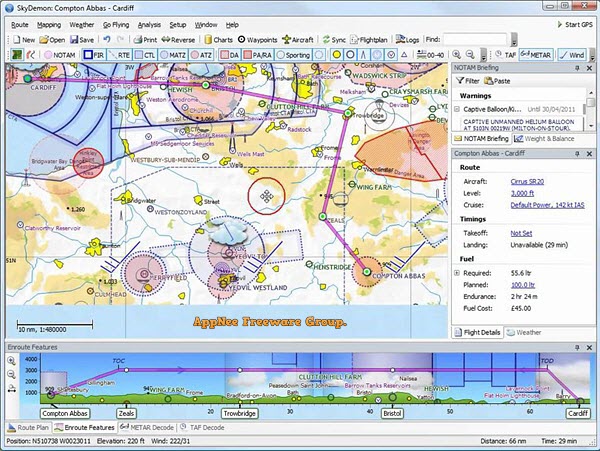
SkyDemon is a flight planning and navigation software developed by Divelements from United Kingdom, mainly suitable for providing pilots with required data during aviation flight. It provides detailed aeronautical data and charts to ensure pilots have all the information they need for any flight, keeping the aeronautical process safe.
SkyDemon’s flight planning feature is designed to make flight planning less tedious by delivering the best aviation summary information directly to your fingertips in real-time as you explore charts and try out potential journeys. Its real-time briefing data mainly includes NOTAM, airport documents and maps, TAF, METAR and wind direction aloft. It can help you plan your trip, brief you on potential hazards, prepare you to fly and analyze track records. At the same time, SkyDemon will give you the confidence to fly further and more interesting places.
SkyDemon’s navigation feature is designed to keep you safe and well-informed during your flight. You’ll spend less time worrying about navigating and more time looking out the window and enjoying this experience. During the flight, SkyDemon will effortlessly guide you between waypoints and notify you of potential hazards. At target airports, you can use geo-referenced tiles for reference, use detailed local maps as a guide for approaches, or simply use them to get around an unfamiliar taxiway.
In short, SkyDemon is a very practical program that many pilots around the world use to plan their flights. It makes this process not so tedious and more interesting, you will have fun from the convenience and be glad that you got to know this application. It offers a lot of aeronautical information, all of which will be available with one click. Plus, you will get a host of features that will help you feel confident to fly further and explore more places of interest.
// Key Features //
| Flight Planning |
|
| GPS Navigation |
|
// Fan Made Demo Video //
// System Requirements //
- Internet connection required for live weather update while in flight.
- Microsoft Edge WebView2 Runtime
// Edition Statement //
AppNee provides the SkyDemon Edition multilingual full installers and universal keygen for Windows 32-bit & 64-bit.
// Installation Notes //
for v3.15.x+:
- Register a Personal Trial account on official site (free trials of SkyDemon may be not available currently)
- Download and install SkyDemon from official site
- Login with your trial account info (to generate the trial license file)
- Run keygen, click ‘Get From Trial File‘, open the trial license file, and click ‘Generate‘ to generate a Full license file
- Done
// Related Links //
// Download URLs //
| Version | Download | Size |
| for Windows | ||
| Latest |  |
n/a |
| Universal Keygen | ||
| v3.15.x+ |  |
61.1 KB |
(Homepage)
| If some download link is missing, and you do need it, just please send an email (along with post link and missing link) to remind us to reupload the missing file for you. And, give us some time to respond. | |
| If there is a password for an archive, it should be "appnee.com". | |
| Most of the reserved downloads (including the 32-bit version) can be requested to reupload via email. |