| Ⅰ | This article along with all titles and tags are the original content of AppNee. All rights reserved. To repost or reproduce, you must add an explicit footnote along with the URL to this article! |
| Ⅱ | Any manual or automated whole-website collecting/crawling behaviors are strictly prohibited. |
| Ⅲ | Any resources shared on AppNee are limited to personal study and research only, any form of commercial behaviors are strictly prohibited. Otherwise, you may receive a variety of copyright complaints and have to deal with them by yourself. |
| Ⅳ | Before using (especially downloading) any resources shared by AppNee, please first go to read our F.A.Q. page more or less. Otherwise, please bear all the consequences by yourself. |
| This work is licensed under a Creative Commons Attribution-NonCommercial-ShareAlike 4.0 International License. |
The traditional method of measuring the terrain by hand is time-consuming and you have to go back and remeasure the details immediately if you find a measurement error. Nowadays, we only need to use drones or other equipment to obtain 2D images and data about terrain, then use tools such as 3Dsurvey for image processing to locate the model, generate dense 3D point clouds from aerial images, so as to analyze each geographical location and design the model easily.
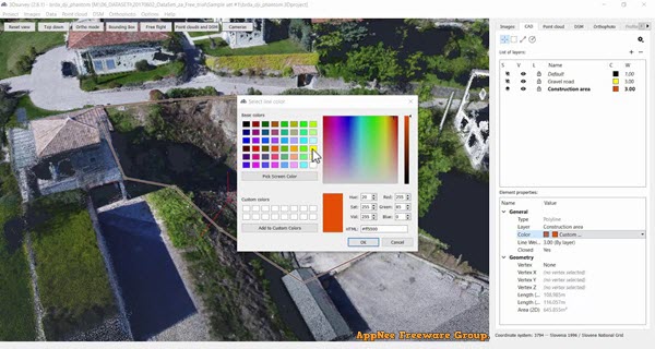
3Dsurvey is a professional and complete 3D land surveying and data processing tool (3D mapping and aerial image processing software) with rich functions and intuitive UI, developed by Modri Planet from Slovenia. It can efficiently process photos taken by all kinds of digital cameras, generate your own ortho-photo maps and digital surface models, quickly and easily calculate volumes, automatically process data according to matching algorithms, and manage inventory in a quick and easy way, so as to help users complete topographic surveying work faster.
3Dsurvey has the function of geographic data analysis, which is of great help to users who need to design terrain models. In addition, it provides photogrammetry, automated classification of point clouds, volume calculation, CAD tools, cross regions, CM-level accuracy, and more. In short, users of land surveying and related work can leave their heavy lifting to 3Dsurvey, and work smarter, faster, and more efficiently than ever before.
// Official Demo Videos //
// System Requirements //
- Microsoft Visual C++ 2010, 2015 Redistributable Packages
// Edition Statement //
AppNee provides the 3Dsurvey multilingual full installers and unlocked files, as well as portable full registered versions for Windows 64-bit only.
// Installation Notes //
for v2.18.1:
- Download and install 3Dsurvey
- Run the activator as administrator, click ‘Start‘, and click ‘Yes‘
- Run program, input any serial like:
- 11111111-1111-1111-1111-111111111111
- Click ‘Next‘, then click ‘Finish‘
- Exit the activator
- Done
*** To make MAP option work correctly, you need to keep the activator running.
for v2.15.1:
- Download and extract 3Dsurvey
- Copy the license file (along with “Modri planet d.o.o” folder) to the following path:
- C:\Users\[user name]\AppData\Local\
- Done
// Related Links //
// Download URLs //
| Version | Download | Size |
| v2.18.1 | 64-bit | 138 MB |
(Homepage)
| If some download link is missing, and you do need it, just please send an email (along with post link and missing link) to remind us to reupload the missing file for you. And, give us some time to respond. | |
| If there is a password for an archive, it should be "appnee.com". | |
| Most of the reserved downloads (including the 32-bit version) can be requested to reupload via email. |